
 Introduction to Rivers
Rivers are flowing bodies of waters. There are rivers on every continent (except Antarctica). Rivers are an important part of the Earth's water cycle and the sculpting of the Earth's topography as they carry huge quantities of water from the land to the sea.
The Course of a RiverRivers generally start at a source, like a snow melt (such as a glacier) or a natural spring. Most rivers flow into a larger body of water, like an ocean, sea, or large lake.
The early course of a river is often in steep, mountain areas, with rapidly-flowing cold water. As a river continues along its course (which is always changing), the surrounding terrain flattens out and the river widens. Rivers often meander (follow a winding path) along their middle course. Tributaries (smaller rivers or streams) and runoff flow into the river, increasing the river's volume (the amount of water it has). Rivers often have increased volume and water speed in the spring, as snow at the river's source melts.
Most rivers end when they flow into a large body of water. The end of the river is called the mouth. At the mouth, there is usually a river delta, a large, silty area where the river splits into many different slow-flowing channels that have muddy banks. New land is created at deltas. Deltas are often triangular-shaped, hence the name (the Greek letter 'delta' is shaped like a triangle).

Stages of a River:
A river rises in high ground ( its source ). It then flows down a slope ( its course ) until it reaches the sea ( its mouth ).
Rivers are usually looked at as having three parts or courses.
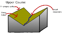
The upper course or the youthful stage is the highest section which is found in the mountains or hills. Here the river erodes a v-shaped valley, the path is fairly straight and it flows downhill steeply. The landforms that are common in this course of the river are waterfalls, gorges and v shape valleys.
Waterfalls
Formation
Different rates of erosion
Waterfalls are usually found in the upper course of a river in the hills or mountains. Waterfalls form when there is a hard layer of rock covering a soft layer of rock.
Water flows over hard rock. When it reaches the soft rock, the water starts to erode or wear away the soft rock. Over thousands of years, the soft rock is eroded and the river begins to cut down vertically into the rock. This makes a cliff over which the water can topple. Over time, the cliff becomes steeper and deeper and a waterfall is formed. At the bottom of the waterfall a plunge pool is created. Some of the water splashes onto the cliff and makes a large, hollow plunge pool by a process called undercutting.

Glaciers
Some waterfalls are made by glaciers. During the last Ice Age (about 10 000 years ago), the pressure of the ice in glaciers cut deep valleys into the mountains. Smaller valleys have been left hanging above the larger valleys. Waterfalls are found where the smaller valleys join the larger valleys. The river flowing through the valleys has to fall many metres to join the main river below.

V-Shape Valleys
Rivers flow through V-shaped valleys in their upper course. V-shaped valleys are usually found in the mountains and hills. They are so called because they often have very steep sides.
V-shaped valleys are formed by erosion. The river carries stones and rocks in its water. The force of the water and the grinding of rocks and stones cut down into the river bedto carve out a valley. Over time the valley becomes deeper and wider.

In the upper course of a river, water flows quickly through a narrow channel with a steep gradient; as it does so it cuts downwards. This vertical erosion results in a number of distinctive landforms including the steep sloping v-shaped valley through which the river flows in its upper course.
Click on the link belwo to see a short clip on the formation of V-Shape Valleys:
http://www.lighthall.solihull.sch.uk/Internet%20site/Subjects/Geography/River%20website/Pages/v%20shaped%20valley.htm#
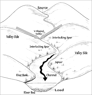
V-Shape Valley and Interlocking Spurs
Vertical erosion (in the form of abrasion, hydraulic action and solution) in the river channel results in the formation of a steep sided valley
Over time the sides of this valley are weakened by weathering processes and continued vertical erosion at the base of the valley
Gradually mass movement of materials occurs down the valley sides, gradually creating the distinctive v-shape.
This material is then gradually transported away by the river when there is enough energy to do so.As the river flows through the valley it is forced to swing from side to side around more resistant rock outcrops (spurs). As there is little energy for lateral erosion, the river continues to cut down vertically flowing between spurs of higher land creating interlocking spurs.
Click on the link below to see a great animation of the formation of interlocking spurs:
http://www.cleo.net.uk/resources/displayframe.php?src=308/consultants_resources%2F_files%2Fintespur2.swf
An interlocking spur is a natural feature which occurs in a river's upper course, where upward erosion is the dominant force in determining the river's course. As the river wanders between banks that are far apart, the promontories of the hills tend to jut out into the river valley in a staggered formation, interlocked together in a formation like the teeth of a zip. These promontories are referred to as interlocking spurs.
While similar in general appearance, the mechanism behind the formation of interlocking spurs is different than that behind If the valley experiences glaciation, the interlocking spurs are foreshortened as the tips are sheared off. These sheared spurs are referred to as truncated spurs.
In simple language, basically what happens is when a river is not eroding vertically but also eroding side to side( like a snake). Te river erodes side to side to avoid boulders act. This process of "snake" repeats, forming spurs of higher land on either side of the valley
No comments:
Post a Comment