Jnr. Cert timetable
http://www.examinations.ie/exam/Written_JC_09_EV.pdf
Leaving Cert timetable
http://www.examinations.ie/exam/Written_LC_EV_2009.pdf

Friday, February 27, 2009
Tuesday, February 24, 2009
Rivers
 Introduction to Rivers
Rivers are flowing bodies of waters. There are rivers on every continent (except Antarctica). Rivers are an important part of the Earth's water cycle and the sculpting of the Earth's topography as they carry huge quantities of water from the land to the sea.
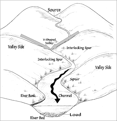
The Course of a RiverRivers generally start at a source, like a snow melt (such as a glacier) or a natural spring. Most rivers flow into a larger body of water, like an ocean, sea, or large lake.
The early course of a river is often in steep, mountain areas, with rapidly-flowing cold water. As a river continues along its course (which is always changing), the surrounding terrain flattens out and the river widens. Rivers often meander (follow a winding path) along their middle course. Tributaries (smaller rivers or streams) and runoff flow into the river, increasing the river's volume (the amount of water it has). Rivers often have increased volume and water speed in the spring, as snow at the river's source melts.
Most rivers end when they flow into a large body of water. The end of the river is called the mouth. At the mouth, there is usually a river delta, a large, silty area where the river splits into many different slow-flowing channels that have muddy banks. New land is created at deltas. Deltas are often triangular-shaped, hence the name (the Greek letter 'delta' is shaped like a triangle).

Stages of a River:
A river rises in high ground ( its source ). It then flows down a slope ( its course ) until it reaches the sea ( its mouth ).
Rivers are usually looked at as having three parts or courses.
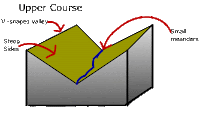
The upper course or the youthful stage is the highest section which is found in the mountains or hills. Here the river erodes a v-shaped valley, the path is fairly straight and it flows downhill steeply. The landforms that are common in this course of the river are waterfalls, gorges and v shape valleys.
Waterfalls
Formation
Different rates of erosion
Waterfalls are usually found in the upper course of a river in the hills or mountains. Waterfalls form when there is a hard layer of rock covering a soft layer of rock.
Water flows over hard rock. When it reaches the soft rock, the water starts to erode or wear away the soft rock. Over thousands of years, the soft rock is eroded and the river begins to cut down vertically into the rock. This makes a cliff over which the water can topple. Over time, the cliff becomes steeper and deeper and a waterfall is formed. At the bottom of the waterfall a plunge pool is created. Some of the water splashes onto the cliff and makes a large, hollow plunge pool by a process called undercutting.

Glaciers
Some waterfalls are made by glaciers. During the last Ice Age (about 10 000 years ago), the pressure of the ice in glaciers cut deep valleys into the mountains. Smaller valleys have been left hanging above the larger valleys. Waterfalls are found where the smaller valleys join the larger valleys. The river flowing through the valleys has to fall many metres to join the main river below.

V-Shape Valleys
Rivers flow through V-shaped valleys in their upper course. V-shaped valleys are usually found in the mountains and hills. They are so called because they often have very steep sides.
V-shaped valleys are formed by erosion. The river carries stones and rocks in its water. The force of the water and the grinding of rocks and stones cut down into the river bedto carve out a valley. Over time the valley becomes deeper and wider.

In the upper course of a river, water flows quickly through a narrow channel with a steep gradient; as it does so it cuts downwards. This vertical erosion results in a number of distinctive landforms including the steep sloping v-shaped valley through which the river flows in its upper course.
Click on the link belwo to see a short clip on the formation of V-Shape Valleys:
http://www.lighthall.solihull.sch.uk/Internet%20site/Subjects/Geography/River%20website/Pages/v%20shaped%20valley.htm#
V-Shape Valley and Interlocking Spurs
Vertical erosion (in the form of abrasion, hydraulic action and solution) in the river channel results in the formation of a steep sided valley
Over time the sides of this valley are weakened by weathering processes and continued vertical erosion at the base of the valley
Gradually mass movement of materials occurs down the valley sides, gradually creating the distinctive v-shape.
This material is then gradually transported away by the river when there is enough energy to do so.As the river flows through the valley it is forced to swing from side to side around more resistant rock outcrops (spurs). As there is little energy for lateral erosion, the river continues to cut down vertically flowing between spurs of higher land creating interlocking spurs.
Click on the link below to see a great animation of the formation of interlocking spurs:
http://www.cleo.net.uk/resources/displayframe.php?src=308/consultants_resources%2F_files%2Fintespur2.swf
An interlocking spur is a natural feature which occurs in a river's upper course, where upward erosion is the dominant force in determining the river's course. As the river wanders between banks that are far apart, the promontories of the hills tend to jut out into the river valley in a staggered formation, interlocked together in a formation like the teeth of a zip. These promontories are referred to as interlocking spurs.
While similar in general appearance, the mechanism behind the formation of interlocking spurs is different than that behind If the valley experiences glaciation, the interlocking spurs are foreshortened as the tips are sheared off. These sheared spurs are referred to as truncated spurs.
In simple language, basically what happens is when a river is not eroding vertically but also eroding side to side( like a snake). Te river erodes side to side to avoid boulders act. This process of "snake" repeats, forming spurs of higher land on either side of the valley
Thursday, February 19, 2009
Volcanoes
Location of Volcanoes Worldwide

This is a video about volcanoes and how they are formed.
What are volcanoes?
A volcano is an opening, or rupture, in a planet's surface or crust, which allows hot, molten rock, ash, and gases to escape from below the surface. Volcanic activity involving the extrusion of rock tends to form mountains or features like mountains over a period of time.
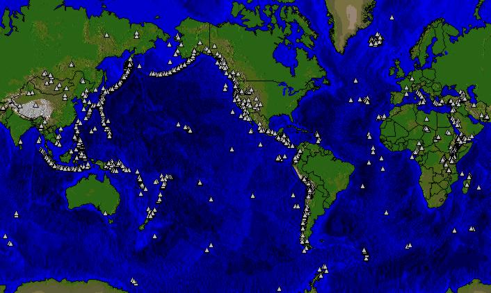
Volcanoes are generally found where tectonic plates are diverging or converging. A mid-oceanic ridge, for example the Mid-Atlantic Ridge, has examples of volcanoes caused by "divergent tectonic plates" pulling apart; the Pacific Ring of Fire has examples of volcanoes caused by "convergent tectonic plates" coming together.
By contrast, volcanoes are usually not created where two tectonic plates slide past one another. Volcanoes can also form where there is stretching and thinning of the Earth's crust (called "non-hotspot intraplate volcanism"), such as in the African Rift Valley, the Wells Gray-Clearwater volcanic field and the Rio Grande Rift in North America and the European Rhine Graben with its Eifel volcanoes.
Volcanoes can be caused by "mantle plumes". These so-called "hotspots" , for example at Hawaii, can occur far from plate boundaries. Hotspot volcanoes are also found elsewhere in the solar system, especially on rocky planets and moons.
Divergent plate boundaries
At the mid-oceanic ridges, two tectonic plates diverge from one another. New oceanic crust is being formed by hot molten rock slowly cooling and solidifying. The crust is very thin at mid-oceanic ridges due to the pull of the tectonic plates. The release of pressure due to the thinning of the crust leads to adiabatic expansion, and the partial melting of the mantle causing volcanism and creating new oceanic crust. Most divergent plate boundaries are at the bottom of the oceans, therefore most volcanic activity is submarine, forming new seafloor. Black smokers or deep sea vents are an example of this kind of volcanic activity. Where the mid-oceanic ridge is above sea-level, volcanic islands are formed, for example, Iceland.
Lava enters the Pacific at the Big Island of Hawaii
Convergent plate boundaries
Subduction zones are places where two plates, usually an oceanic plate and a continental plate, collide. In this case, the oceanic plate subducts, or submerges under the continental plate forming a deep ocean trench just offshore. Water released from the subducting plate lowers the melting temperature of the overlying mantle wedge, creating magma. This magma tends to be very viscous due to its high silica content, so often does not reach the surface and cools at depth. When it does reach the surface, a volcano is formed. Typical examples for this kind of volcano are Mount Etna and the volcanoes in the Pacific Ring of Fire.
Hotspots
Hotspots are not usually located on the ridges of tectonic plates, but above mantle plumes, where the convection of the Earth's mantle creates a column of hot material that rises until it reaches the crust, which tends to be thinner than in other areas of the Earth. The temperature of the plume causes the crust to melt and form pipes, which can vent magma. Because the tectonic plates move whereas the mantle plume remains in the same place, each volcano becomes dormant after a while and a new volcano is then formed as the plate shifts over the hotspot. The Hawaiian Islands are thought to be formed in such a manner, as well as the Snake River Plain, with the Yellowstone Caldera being the part of the North American plate currently above the hotspot.
Wednesday, February 18, 2009
The Rock Cycle


“Rocks are continually formed, modified, destroyed and reconstructed as part of the rock cycle. They are formed and modified by endogenic (internal) forces; they are destroyed by exogenic (external) forces of erosion on exposure to weather and climate; they are reconstituted by the deposition of sediments.”
For this statement students need to have a knowledge of the basic rock classification of igneous, sedimentary and metamorphic. They should be able to give both Irish and world examples of each rock type.
For this statement students need to have a knowledge of the basic rock classification of igneous, sedimentary and metamorphic. They should be able to give both Irish and world examples of each rock type.
Igneous rocks
Igneous rocks are usually divided into two groups-intrusive (plutonic) and extrusive (volcanic) rocks. Granite is the most common of the intrusive rocks and it underlies most of the continents. Basalt is the most common of the extrusive rocks and it underlies most of the oceans. Granite was formed when magma intruded into the earth’s crust. This cooled slowly over a long period of time and formed a coarse grained rock that is very resistant to erosion. You need to know about the colour, the constituent minerals and the uses of granite. Major locations in Ireland include the Mournes and the Dublin-Wicklow mountains. Basalt was formed when lava was exposed at the surface and cooled quickly. It is a fine-grained, dull coloured rock and it is noted for its resistance (hardness). Sometimes, if it cools rapidly, it can split into hexagonal columns. The Giant’s Causeway is a good example of this. Basalt often results in the formation of a plateau---good examples are the Antrim-Derry Plateau and the Deccan of India.
Igneous rocks are usually divided into two groups-intrusive (plutonic) and extrusive (volcanic) rocks. Granite is the most common of the intrusive rocks and it underlies most of the continents. Basalt is the most common of the extrusive rocks and it underlies most of the oceans. Granite was formed when magma intruded into the earth’s crust. This cooled slowly over a long period of time and formed a coarse grained rock that is very resistant to erosion. You need to know about the colour, the constituent minerals and the uses of granite. Major locations in Ireland include the Mournes and the Dublin-Wicklow mountains. Basalt was formed when lava was exposed at the surface and cooled quickly. It is a fine-grained, dull coloured rock and it is noted for its resistance (hardness). Sometimes, if it cools rapidly, it can split into hexagonal columns. The Giant’s Causeway is a good example of this. Basalt often results in the formation of a plateau---good examples are the Antrim-Derry Plateau and the Deccan of India.
Sedimentary Rocks
These rocks are formed by compressed sediments or fragments and often form on lakebeds or under the sea. There are three basic categories of sedimentary rocks. Students should know how each type are formed and be able to give examples of each. Sedimentary rocks form in layers (bedding planes). The three groups of sedimentary rocks are:
Organic sedimentary rocks - these are formed from the compacted remains of living things. Limestone and Peat are obvious examples. Ireland’s limestone was formed under the sea and covers large areas of the country. However, much of this is covered by glacial till (see glaciation) but is exposed in areas such as the Burren in Co. Clare. Limestone is also very evident in areas such as the Karst region of Croatia.
Inorganic (Mechanical) sedimentary rock - these are formed from the compacted remains of the broken down particles of other rocks; Sandstone and Shale are examples. Sandstone is the second most common rock found in Ireland and can be found in the Magillicuddy Reeks, Co. Kerry.
Chemically Derived sedimentary rocks - these include gypsum and rock salt. Gypsum is found in Co.Cavan. However, the most prized deposits associated with chemical deposition are oil and gas. Significant deposits of gas have been found off both the south and west coasts of Ireland.
Metamorphic Rocks
Metamorphic rocks are rocks that have been changed due to great heat and/or pressure. They were originally either igneous or sedimentary. This change is due to either igneous activity, where great heat changes the original rock on contact or to tectonic activity, where converging plates generate heat and pressure thus causing rocks to change their state. Typical examples of metamorphic rocks include-Quartzite (from sandstone) and Marble (from limestone).This section also requires students to be familiar with the rock cycle. In other words, they should have both Irish and international information with regard to one of the following: mining; oil/gas exploration extraction of building materials; geothermal energy production.
Metamorphic rocks are rocks that have been changed due to great heat and/or pressure. They were originally either igneous or sedimentary. This change is due to either igneous activity, where great heat changes the original rock on contact or to tectonic activity, where converging plates generate heat and pressure thus causing rocks to change their state. Typical examples of metamorphic rocks include-Quartzite (from sandstone) and Marble (from limestone).This section also requires students to be familiar with the rock cycle. In other words, they should have both Irish and international information with regard to one of the following: mining; oil/gas exploration extraction of building materials; geothermal energy production.
Click the link below to have a look at an animation of the Rock Cycle
Below is a video about rocks and the rock cycle
Friday, February 13, 2009
Jnr. Cert. Revision Sheets
Geography Mid Term Revision
“Large scale tourism can cause major problems for busy tourist regions”.
Describe THREE problems associated with large scale tourism.
(12 mark JC Higher Level Question 2005)
Explain how any TWO of the following influence population densities throughout the world.
Soils
Relief (shape of the land surface)
Mineral Wealth
(8 mark question JC Higher Level Question 2005)
Describe TWO problems caused by low population density which affect the country labelled x (Mali) on the map.
(8 mark question JC Higher Level Question 2005)
Describe TWO ways in which rocks may be of economic use to people.
(12 mark question JC Higher Level Question 2005)
a) Name one example of organised international migration.
b) Describe two reasons why this organised migration took place.
c) Describe one long term effect of this migration in the destination country.
(10 mark question JC Higher Level Question 2005)
Explain TWO ways in which war and spending of money on arms have prevented economic development in ONE named country of your choice.
(10 mark question JC Higher Level Question 2005)
a) Suggest one reason why there is low population density in the West of Ireland
b) Suggest one reason why there is high population density in the Southern and Eastern region of Ireland.
(4 mark question JC Higher Level Question 2004)
8 a) Describe and explain one reason for the high population density in the Southern and Eastern region of Ireland.
b) Describe and explain one reason for the low population density in the West of Ireland.
(12 mark question JC Higher Level Question 2004)
9. Describe TWO problems that might arise in an area of high population density OR an area of low population density.
(10 mark question JC Higher Level Question 2004)
10. Answer question 1, 4, 5, and 7 on page 174 of your book.
Coastal Processes Summary Sheet
Waves are caused by the _____ passing over the surface of the sea causing the water to move. The size of the wave will increase with ___ _______ __ ___ ______and the length of the sea (called_______) over which it passes
The foamy, white water that rushes towards the shore is called the ______ and the water that moves back down the shore is called the________. The swash and backwash _____________________________________________________________.
Constructive waves are waves that occur during _______ ______. They have limited _______ and most of it is used by the swash to transport material and _______ material.
Destructive waves are waves that occur in _______ ______. They have much more energy and have very strong __________. There is a lot of erosion.
Constructive Waves
Destructive Waves
Coastal Erosion: The coast is eroded by __________ Waves
1
2
3
4
5
Features of Coastal (sea) Erosion
Cliffs, E.g. __________________
Diagram
Formation:
Bays and Headlands, E.g. ____________________
Diagram
Formation:
Sea Cave, Blowholes, Sea Arch, Sea Stack and Sea Stump. E.g. ____________
Diagram
Formation:
Transportation by the Sea is by a process of ___________ _________
Diagram
Process:
Features of Coastal (sea) Deposition
Beaches & Storm Beaches
Sand Dunes
Sand Spits
Bars and Lagoons
Tombolo
Human Activities Coastal Protection
1.
2.
3.
4.
Rivers
As a flows from its source to its mouth, its gradient (slope) and valley shape change. There are 3 different stages in the course of a river, i.e.:
* _______________________________
* _______________________________
* _______________________________
Life cycle of a River
River terms:
Term
Definition
Source
The high ground that separates one river basin from another.
Estuary
Mouth
The point at which a tributary joins the river
A small stream or river that joins up with a larger one
Basin
Course
All the material being carried by the river
Flood plain
The Life Cycle of a River
Like humans, rivers go through a life cycle: Youthful stage à Mature stage à Old-stage
The Youthful stage (Upper course)
The river begins its life-cycle in the _________________. Its aim is to reach the lake or sea as quickly as possible so it makes its way downwards by means of v_________
e____________. Both its vol____ and load are small. Vertical erosion loosens material along the ____ of the river.
A river erodes in four ways or processes.
1______________________________________________________________________________________________________________________________________________________________________________________________________________
2______________________________________________________________________________________________________________________________________________________________________________________________________________
3______________________________________________________________________________________________________________________________________________________________________________________________________________
4______________________________________________________________________________________________________________________________________________________________________________________________________________
The amount of erosion that takes place depends on:
1:Volume:_______________________________________________________________________________________________________________________________________
2:Velocity:_______________________________________________________________________________________________________________________________________
3:Underlyingrock:_________________________________________________________________________________________________________________________________4:Load:________________________________________________________________________________________________________________________________________
Landforms/ Features of the Youthful stage
V shaped valleys
Interlocking spurs
Waterfalls
V-Shaped Valleys
The river is starting its life-cycle in the mountains. Both the volume of the water and the ______ are small. The river wants to enter the lake or sea as quickly as possible so it starts to erode _____wards forming a ___ shaped valley, e.g. the youthful stage of the river Liffey.
Formation of a V-shaped valley
Interlocking Spurs
In the ____________ stage the river does not have enough power to go through obstacles, e.g. g______e so it goes ___________ them forming interlocking _________. Interlocking _________ are areas of high ground that jut out from _______ sides of a young __________ valley and ______ into one another like pieces of a jigsaw.
V-Shaped valley with interlocking spurs
Waterfalls
Waterfalls occur when the river meets a layer of ________ rock and soft rock. The ______ rock will be eroded much faster than the _______ rock causing the riverbed to steepened forming a __________. The force of the falling w_______ cuts a hole called a _________ pool. The falling ________ also cuts under the ____________ to form a over_____. This eventually ___________. This process repeats itself and the waterfall gradually __________ upstream. A good example of a ____________ the Torc Waterfall in ________________.
Formation of a Waterfall
Landforms/ Features of the Mature stage
In the ________ stage the river’s _________ has increased because many _________ have joined it. In this stage _________ erosion takes place. In the Mature Stage of a river, ____________ erosion leads to the following features:
Meanders
Ox-box lakes
Meanders
Meanders are c_______ or loops that develop along the course of a river. Meanders are formed by __________ on the outer bank and ___________ on the inner bank. Meanders appear as bends along the river’s course. As the river flows around a slight _______, the water on the ____side bank flows more __________ and has ________ power to erode the river bank. The water on the ________ bank flows more s_________, and as a result the river will ___________ some of its load there. As the river flows downstream the meanders become more ______________. Meanders are found along the course of the R. Shannon.
Ox-Bow Lakes
An Ox bow lake is a ______________ shaped lake found on the _________ __________
of a river. It is a feature of e__________ and d___________. Ox bow lakes develop from well-developed __________. Erosion continues to take place on the _______ bank and the _______ of the land becomes narrower. During a __________ the river may _____ through it. The river now flows __________ ___________ instead of following the meander. As the sediment is d________ed, it seals both ends of the abandoned meander loop – thus forming an ____ ______ lake. Example – R. _________.
Formation of an Ox Bow Lake
Landforms/ Features of the Old stage
The river is now entering the end of its life c________. All the eroded and transported material is now _____________ along the bed and banks of the river. Two features of the old stage include:
Levees
Deltas
Levees
Levees are _________ ________ ___ ____________ found along the banks of some rivers in their ____ stage. The river is now flowing over f____ land. The river _______
material on its bed causing the water to rise. Sometimes this may cause the river to o___f_____ depositing its material on its_______. These banks are ________ and are often reinforced to prevent ________and damaging low-lying land, e.g. R. S_____.
Levees develop in the old stage of a river
Deltas
Deltas are formed at the _______ ___ _ _______. When a river flows into the sea, it ____
Its speed and d________ its load of sediment. If the tides and currents are not strong enough to carry it all out to sea, the deposits begin to _______ ___. The m______ of the river soon becomes clogged and the river breaks up into smaller _________ called dis____________. Example –Mouth of the R. N_____.
Delta
River Transportation
A river is an agent of t_________t, carrying material from upland to ___land areas. It can do so in the following ways:
à Rolling _______________________________________________________________
à Bouncing _____________________________________________________________
à Suspension ___________________________________________________________
à Solution ______________________________________________________________
River transportation
Case study of a river – The Shannon
Sunday, February 8, 2009
Junior Cert Cycle and Exam
Junior Cycle Geography - Exam Guide (H)
Exam Structure & Strategy
Level Higher
Time
2 hours (120 minutes)
Marks
150
Structure
Section 1 – Folder (60 marks)All 20 short questions to be answered on the folder provided and returned with your answer-book.There is an either/or choice within 3 of the questions
Section 2 (90 marks)Answer 3 from 5 longer questions.
Each question carries 30 marks
Exam StrategyTiming: Allow 10 minutes to read the paper carefully at the start, pick up information and terms from the questions, and jot down any important items for use later in the exam. Allow 40 minutes for Section 1 (Folder question) and stick to this time plan.
For Section 2, where you are required to answer three out of five longer questions, allow 20 minutes for each question. Choose these questions carefully and move on to the next question when you have reached the time allowed – it is always easier to get the ‘attempt’ marks for the next question than the final ‘polishing’ marks for the previous one.
Leave 10 minutes at the end to review your paper and spot any significant errors or items left out. It is tempting to keep writing furiously up to the final bell, but a nervous mistake made earlier on the short questions or in map reading could cost you a grade, if not rectified.
Walk-through the paper (Question by question) – JC Geography (H)
Section 1 - Folder
These short questions can range over all sections of the course and will typically examine you on physical geography (including climate), on human geography (including problems of underdeveloped countries), and on the Ordnance Survey map.
When answering these Folder questions, ensure that you answer all 20 of them. If in doubt make your best guess – there are no marks lost for trying.
In the three questions out of the twenty where you are given an either/or choice, answer both parts. A lot of these questions are merely testing if you can read the information given to you in the various lists of statistics or pie-charts or bar-graphs given on the paper. Therefore, it is vital that you stay calm and read each question carefully. At the same time remember that you have to answer 20 questions in approximately 40 minutes, this means that you have just two minutes to answer each of these short questions.
You need a total of 60 marks to pass Junior Cert. Geography. Section 1 (the Folder Section) carries exactly 60 marks. A good performance on this section will see you well on your way to a good grade overall in this exam.
Section 2 – Longer Questions
These general questions will range over the sections on Social, Economic and Physical Geography and you can expect at least one question on Aerial Photographs and Maps.When attempting these questions, remember:
Choice of questions.
Read all questions carefully at the beginning, then decide which three of the five you are going to answer. It is important to read all of the sections of the question before deciding whether to answer it or not. A good illustration of this would be the question entitled “Geography Mix” that came up in 2001; this had four separate sub-sections which asked on (a) the location of industry, (b) migration, (c) Irish sea-fishing and (d) Urban Planning. In other words, if you picked this question just because you knew about the location of industry, then you might have been a bit surprised when you arrived at section (c) on sea-fishing. Every year you will find that there is a choice between questions on physical geography, on human geography and on maps and photographs.
Answering Style
The style of answering will vary a little from question to question. However, in general, it can be noted that each question covers a number of parts (usually three) and each of these parts usually carries the same amount of marks.The best way to answer each question is in point form or in short concise sentences which clearly try to answer the question asked. Make a statement and then develop that same statement. Example (a): if you are asked to give a reason why people migrate to large towns or cities, then you could say “Because of jobs” (this is your statement). Then you would develop this by saying “Dublin has lots of jobs in manufacturing” (one development point) “e.g. computers” (second development point). Example (b): if you were asked to “Explain why the Amazon is hotter than Northern Canada”, you could say “the Amazon is nearer the Equator” (this is your statement) and “the sun’s rays are at a higher angle” (one development point). Then you could follow that with “there is more concentration of heat than in Northern Canada” (the second development point). Remember – make a clear short statement, then develop it by giving examples or explaining the point in more detail.
Use of Diagrams
With the exception of the Aerial Photograph and the Ordnance Survey questions, the drawing of maps and diagrams is not especially important at Junior Cert. Level. Most of the questions come with diagrams already drawn. However, if it is necessary to draw a diagram, then do it quickly and in pencil. Pencil allows you to rub out your work if you are not happy with it. Use colouring pencils to finish it off, if you wish, but these are optional. You can always just shade in the different areas with your ordinary pencil. Remember, this is not an art-exam so you are not expected to spend ages trying to produce a masterpiece.
Ordnance Survey and Photograph Questions
Sometimes there are separate questions and sometimes there is an overlap where the map and photo questions are combined. You will often be asked to draw a sketch map of some features from the Ordnance Survey Map or the photo. N.B. A sketch map is not a tracing. If a tracing is given when asked for a sketch map, then you will lose at least half the marks available –sometimes more.
When drawing sketch maps:
Use a pencil – it is easier to rub out
Always draw a frame for your sketch map. The frame should be the same shape as the photograph or Ordnance Survey map you are sketching
Do not draw a sketch map that is more than half the size of the answer sheet you are using. It will take too long and be more difficult to do.
Give a title to your sketch map.
Give a key to it also, as this will avoid over-crowding on your sketch.
Put a little colour into your sketch if you feel you can spare the time. It is not essential to use colour.
You will often be asked to give examples of specific features on the Ordnance Survey Map. When referring to these features, make sure to give four-figure grid references if at all possible. Remember to include the sub-zone letter before the four figs (e.g. S1749).When referring to roads, give them their full title (e.g. R335 or N77).Remember, any statement that you make about the map or photo must be backed up by a clear reference to the same map or photograph.
Leaving Cert Course and Exam
exam centre - leaving cert
Guide to the Revised Leaving Certificate Geography Syllabus (2006)(Ordinary and Higher level)
The New Leaving Certificate Geography Syllabus will be examined for the first time in 2006. The following general guidelines are intended to assist students and teachers. These guidelines will be updated when further information and modifications to the syllabus have been issued from the Department of Education and Science.
According to the Department, a Sample Paper will be available early in 2006.
Key Points
The syllabus for Ordinary Level is presented in the form of Core and Elective units (see below).
The syllabus for Higher Level is presented in the form of Core, Elective and Optional units (see below).
The ‘Field - Study’ question is now called the ‘Geographical Investigation’. Under the old syllabus this was optional but in its new format as a ‘Geographical Investigation’ it is now compulsory and must be handed in prior to the written exam. The date for the completion of the Geographical Investigation has yet to be set but it will probably be between January and April of 6th Year.
There will be separate examinations for Higher Level and for Ordinary Level students (same as old syllabus).
The exams will be both of 2 ½ duration.
Higher Level students will answer 5 questions; Ordinary Level students will answer 4 (see below).
Syllabus Structure
The revised Geography syllabus has core, elective and optional (higher level only) units.
There are only 3 Core units which all must study:
Core Unit One – Patterns and Processes in the Physical Environment.
Core Unit Two – Regional Geography.
Core Unit Three – Geographical Investigation and Skills.
There are 2 Elective Units and all students are required to study one of these:
Elective Unit 4 – Patterns and Processes in Economic Activities; or
Elective Unit 5 – Patterns and Processes in the Human Environment.
There are also 4 Optional Units which are for Higher Level Students only.
Students must select one of these options:
Optional Unit 6 – Global Interdependence ; or
Optional Unit 7 – Geoecology ; or
Optional Unit 8 – Culture and Identity ; or
Optional Unit 9 – The Atmosphere/ Ocean Environment
Core Units
Core Unit One: Patterns and Processes in the Physical Environment. This unit aims to help students understand and interpret the physical landscape. The key topics are:
The Tectonic Cycle (e.g. plate tectonics, the geography of volcanoes and earthquakes).
The Rock Cycle (e.g. igneous, sedimentary and metamorphic rocks; physical and chemical weathering; mass wasting).
Landform Development (e.g. landform associated with particular rock types; fluvial, coastal and glacial processes and their associated landforms).
Human Interaction (e.g. how human activities can impact on the operation of surface processes).
Core Unit Two: Regional Geography.
This unit examines regions at a range of scales and is not based on the study of a list of countries. The key topics are:
The Concept of a Region e.g., climatic, cultural, socio-economic regions.
The Dynamics of Regions – students should study two contrasting Irish Regions (e.g., Dublin and an area in the West); two contrasting European Regions (e.g., one from Scandinavia and/or one from Western/Central Europe and/or one from the Mediterranean; one continental or sub continental region (e.g., South East Asia).
The Complexity of Regions – e.g., E.U. development and expansion; urban growth and the expansion of city regions.
Core Unit Three: Geographical Investigation and Skills
It is expected that students will gain proficiency in a number of geographical skills which will be examined in the context of the terminal written exam and the Geographical Investigation. These skills include Interpretation of Map and Aerial Photo, Interpretation of Figures, graphs and tables. Interpretation of census material and population statistics.
The Geographical Investigation is the key area of study in Core Unit 3 and is compulsory for all students. The topics for any particular year will be selected from a list sent to schools. It is expected that the main work of the investigation will take place in the first term of 6th Year. The investigation will be written up in a standardised reporting booklet provided by the State Examinations Commission.
The investigation must be completed by the 2nd term of 6th Year. It appears at this stage that the topics acceptable for the investigation will be broadly similar to those acceptable for the Field-Study Option in the old syllabus.
Elective Units
One of the two Elective Units must be taken by both Ordinary and Higher Level students.
Elective Unit 4: Patterns and Processes in Economic Activities. This unit examines patterns in economic development at both national and international levels. The unit has four sub-headings:
Economic Development
The Global Economy
Ireland and the E.U.
The Environmental Impact of Economic Activities
Elective Unit 5: Patterns and Processes in the Human Environment. This unit examines population and settlement patterns over space and time. Other topics include the impact of human migration on both donor and receiver regions and a comprehensive analysis of settlement patterns. The unit has two sub-headings:
The Dynamics of Population
The Dynamics of Settlement
Optional Units
N.B. Optional Units are studied by Higher Level students only.
Only one of the four optional units should be studied.
Optional Unit 6: Global Interdependence. This unit looks anew at the traditional view of development studies (i.e. the first-world/ third-world perspective). The unit has close links with Elective Unit 4. Topics include:
How development and underdevelopment are subject to change
The interdependent global economy
Sustainable development
Aid programmes/ the role of NGOs
Optional unit 7: Geoecology. This unit examines the relationship between soils, climate, plants and animals. This relationship is examined at a global level. The unit also focuses on how humans have exchanged existing natural environments. This unit has close links with Core Unit 1. Topics include:
Development of soils
Distinctive biomes created by the pattern of world climates
Optional Unit 8: Culture and Identity. This unit examines the often complex relationship between culture, nationality and identity. Topics include:
Culture and identity and their ties to language, religion and nationality
Nationality and the nation state
Identity as a concept which includes nationality, language, race and religion
Optional Unit 9: The atmosphere/ ocean environment. This unit looks at the dynamic relationship between the oceans and atmosphere and how this can influence global climatic patterns. Topic include:
Pressure; temperature; wind; humidity
Geographical distribution of temperature
The hydrological cycle
Distinctive climate environments
The influence of climatic characteristics on economic development
The Structure of the Examination Paper
There will be separate exam papers for Higher Level and for Ordinary Level students.
Each paper will be of 2 ½ hours duration.
The examination will have an assessment weighting of 80%.
It will consist of questions requiring short answers and multi-part questions requiring more detailed answers.
Longer essay-style discursive answers will be required only in the optional units (Higher Level only).
The Geographical Investigation will have an assessment weighting of 20%. It will be assessed separately.
Higher Level StructureTime: 2 ½ HOURS
Marks
Weighting
Core12 short answer questions(answer 10) 80 marks, 20%
3 Questions (complete one)combining short answers and multipart questions on Core Unit 1 and skills 80 marks, 20%
3 Questions (complete one)combining short answers and multipart questions on Core Unit 2 and skills 80 marks, 20%
Electives3 questions (complete one) combining short answers and multipart questions on Elective 4 or 5 and skills (students answer on only one elective) 80 marks, 20%
Optional Units
3 essay type questions on each optional unit (students will answer on one option only)
80 marks, 20%
Total
400 marks
Investigation Report
100
Total
500
Ordinary Level StructureTime: 2 ½ HOURS
Marks
Weighting
Core12 short answer questions(answer 10) 100 marks, 25%
3 Questions (complete one)combining short answers and multipart questions on Core Unit 1 and skills 100 marks, 25%
3 Questions (complete one)combining short answers and multipart questions on Core Unit 2 and skills 100 marks, 25%
Electives 100 marks, 25%
Total
400 marks
Investigation Report
100
Total
500
Plate Tectonics
A theory that the Earth outer shell consists of a series of rigid plates known as the lithosphere. These plates move in response to convection currents within the mantle. The interactions of the plates at their boundaries yield earthquakes, volcanic activity, ocean trenches, island chains, mountain ranges and other features.
Tectonic plates are sections of the Earth's solid crust that “float” on top of the mantle.
The mantle contains hot molten rock (magma) heated by energy from the earth's core
The earth’s crust is made up of seven main tectonic plates and numerous smaller plates.

There are two main types of tectonic plate.
Oceanic plates are relatively thin (about 6-10 km) and contain very heavy (dense) rocks such as basalt.
Continental plates are considerably thicker (35-40 km) but contain lighter (less dense) rocks such as granite.
The plates fit together like pieces of a large jigsaw. Tectonic plates meet along four main types of plate boundaries.
The tectonic plates are in constant motion travelling at a few centimetres per year.
The ocean floors are continually moving, spreading from the centre and sinking at the edges.
Where plates meet, huge forces build up causing earthquakes and volcanoes and the formation of fold mountains and deep-sea trenches.
Have a look at the different plate boundaries in the world and what type of features they create:
http://geology.com/plate-tectonics.shtml
The video below shows how the continents have drifted apart over millions of years. This theory is known as Continental Drift.
Friday, February 6, 2009
What is Geography?
Geography (from Greek γεωγραφία - geografia) is the study of the Earth and its lands, features, inhabitants, and phenomena. A literal translation would be "to describe or write about the Earth". The first person to use the word "geography" was Eratosthenes (276-194 B.C.). Four historical traditions in geographical research are the spatial analysis of natural and human phenomena (geography as a study of distribution), area studies (places and regions), study of man-land relationship, and research in earth sciences. Nonetheless, modern geography is an all-encompassing discipline that foremost seeks to understand the Earth and all of its human and natural complexities-- not merely where objects are, but how they have changed and come to be. As "the bridge between the human and physical sciences," geography is divided into two main branches - human geography and physical geography.
Subscribe to:
Posts (Atom)